


I have always felt it strange that people(including me) upload a photo of themselves standing at Meesapulimala(2640 meters) claiming it to be the highest peak in South India after Anamudi when there is clearly another peak to the north which looks a bit taller. So, we set out to test it out for ourselves.
I did quite a lot of homework for this trek this time. I referred to old US topographic maps and realised that what I suspected was quite right. The peak to the north was indeed taller and is named 'Manna Malai' and has a height of about 2659 meters(8724 feet). Going by the maps, this was clearly a different peak from Meesapulimala which is the peak that everyone mistakes to be the second highest peak in the western ghats and has a height of only 2640 meters(8661 feet). Google Earth also proved this theory when I hovered above the peaks to check the altitude.

Notice the Manna Malai peak marked at 8724 feet in this US Topo map and another 8661 feet high unmarked peak to its south which is Meesapulimala.
Another map provided by the Kannan Devan Hill Plantations Company also stands by this theory.

We took a jeep to Suryanelli from Bodi from where we headed to Kolukkumalai on the old and familiar back-breaking jeep track. Suryanelli seemed to resemble heaven at that golden hour. The person driving the jeep was very friendly and he told us a lot of interesting things about the place.


We made our way to the peak from the Kolukkumalai side this time instead of the Rhodo Valley route from Kerala that we had taken during our previous trek. This turned out to be a very demanding and exhausting trek compared to the Rhodo Valley route. The visibility was very bad and we slowly made our way to higher altitudes guided by our GPS. The path was full of elephant dung and we were very cautious as the trail was extremely bushy and we were afraid of running into an elephant. At places, the trail looked beautiful and at places, it would turn into a thorn massage session.

After some time, we entered the grasslands and the terrain turned steep. With poor visibility adding to the woes, we had no clue as to where we where going except for the GPS that became our saviour. Rohith almost stepped on a snake before it immediately sped away from the scene. We also saw a few Kurinji flowers on the way. After about 2 hours, we made it to the peak of Meesapulimala and my GPS read 2640 meters just as it had read the previous time I had summitted it. Soon, Karthik joined us at the peak and by then, Rohith, Deepak and me had had our brunch at the peak. We took a brief rest and proceeded to climb the taller peak to the north. Meanwhile, Arunachalan and Arivazhagan had started their Meesapulimala ascent as well.
We descended towards the Rhodo valley and started trekking on the ridge that also marks the TN-Kerala border. The climb was steep and we could feel it taking a toll on us. The peak seemed to be very close but we felt like it was taking an eternity to reach its peak. I got reminded of these three golden lines of mountaineering:
It is always harder than it looks. It is always taller than it looks. It is always farther than it looks.
Rohith and I were climbing at the front and Deepak and Karthik were trailing us by about 50 meters. All of a sudden, Rohith and I realised that the ridge was no longer climbing and we could feel the ridge dropping on three sides. Had we summitted?? I checked my GPS and yes. We were now on the summit. We were at a point higher than any other human in India outside the Himalayas. My GPS read 2660 meters and this proved that Meesapulimala is not the second tallest peak in south India. That credit goes to Manna Malai, the peak to the north of Meesapulimala that missed this honour probably because of its extreme proximity to Meesapulimala. The Forest Dept. guides at KFDC Munnar and the guides from the TN side all miss this peak and claim that Meesapulimala is the second highest probably because of ignorance. The peak looked a lot different from that of Meesapulimala and was in fact larger in area. It had a lot of vegetation and most importantly, no sign of any human trail on it. The poor visibility made it impossible for any great views but we returned with the satisfaction of having climbed this monster.
 |
| The suspect peak. Image taken during our previous trek. |
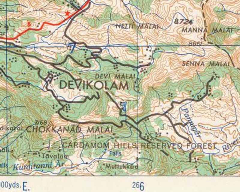
Notice the Manna Malai peak marked at 8724 feet in this US Topo map and another 8661 feet high unmarked peak to its south which is Meesapulimala.
Another map provided by the Kannan Devan Hill Plantations Company also stands by this theory.

We took a jeep to Suryanelli from Bodi from where we headed to Kolukkumalai on the old and familiar back-breaking jeep track. Suryanelli seemed to resemble heaven at that golden hour. The person driving the jeep was very friendly and he told us a lot of interesting things about the place.


We made our way to the peak from the Kolukkumalai side this time instead of the Rhodo Valley route from Kerala that we had taken during our previous trek. This turned out to be a very demanding and exhausting trek compared to the Rhodo Valley route. The visibility was very bad and we slowly made our way to higher altitudes guided by our GPS. The path was full of elephant dung and we were very cautious as the trail was extremely bushy and we were afraid of running into an elephant. At places, the trail looked beautiful and at places, it would turn into a thorn massage session.

 |
| Meesapulimala @2640 meters. |
 |
| Looking towards Manna Malai, 2659 meters |
It is always harder than it looks. It is always taller than it looks. It is always farther than it looks.
Rohith and I were climbing at the front and Deepak and Karthik were trailing us by about 50 meters. All of a sudden, Rohith and I realised that the ridge was no longer climbing and we could feel the ridge dropping on three sides. Had we summitted?? I checked my GPS and yes. We were now on the summit. We were at a point higher than any other human in India outside the Himalayas. My GPS read 2660 meters and this proved that Meesapulimala is not the second tallest peak in south India. That credit goes to Manna Malai, the peak to the north of Meesapulimala that missed this honour probably because of its extreme proximity to Meesapulimala. The Forest Dept. guides at KFDC Munnar and the guides from the TN side all miss this peak and claim that Meesapulimala is the second highest probably because of ignorance. The peak looked a lot different from that of Meesapulimala and was in fact larger in area. It had a lot of vegetation and most importantly, no sign of any human trail on it. The poor visibility made it impossible for any great views but we returned with the satisfaction of having climbed this monster.
 |
| At the peak of Manna Malai. |